
The leading pair have been caught once, only to slip away again – Team Brunel closed to within three miles of Team AkzoNobel at 0700UTC this morning, only to see them boost it back to a 16 mile lead at 13:00UTC. And there is still 30nm of east to west separation (or leverage; distance measured across the fleet perpendicular to the course). And an extended period of light airs ahead of them. Lots of golf left in this hole.
Weather not climate
These strategic reviews rely heavily on the idea of climate zones that the earth’s oceanic climate features distinct bands, lying horizontally and looping the globe, running out from the Equator to the Poles in a mirror image.
When the fleet races from north to south (or vice versa) as they are right now, then they cross through several of these climate zones and the transitions from one type of weather or climate zone to the next become the critical features of the strategic game.
That’s not quite been the case this time around, where we have seen the climate disrupted by large scale weather systems right from the outset – but there have still been transitions. In the last six days we’ve seen them hit and escape a first band of Doldrums, and then enter a second, much bigger section.
Meanwhile Cyclone Gita is the latest disruptor, sucking all the energy out of the atmosphere and leaving a massive hole in its wake. The south-easterly trade winds are almost non-existent, and the path to Auckland looks rocky and long – but it will still involve a transition from their current Doldrums weather into something else. The question is... what?
Backing up
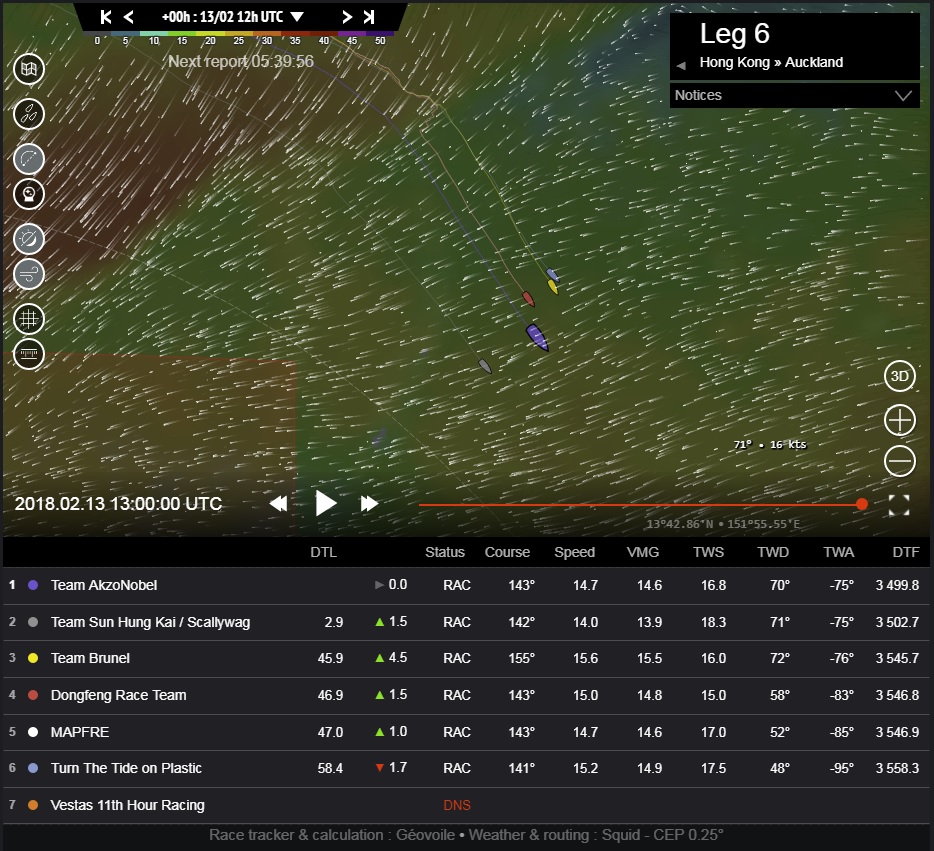
I’m getting ahead of myself, though, let’s back up to Image 1, where we left the fleet at the end of the last Strategic Review at 13:00UTC on the 13th February. The whole fleet had broken free into the north-easterly trade winds, and were aiming for a climate zone transition from the trade winds into the Doldrums.

©Geovoile - Image 1 (Click for larger image)
There was about 90 miles from the east to west wings of the fleet, with the two western boats maintaining a 50nm mile lead over the front of the chasing pack. The forecast and predictions looked solid – a more easterly transition of the Doldrums would pay, and it seemed likely that as the leverage reduced with everyone trying to get east, the eastern boats would make gains courtesy of a wider, faster wind angle.
Oh boy, was I wrong about some of that... but then, so was Joan Vila aboard MAPFRE and Pascal Bidégorry on Dongfeng Race Team.
Predictable trade winds
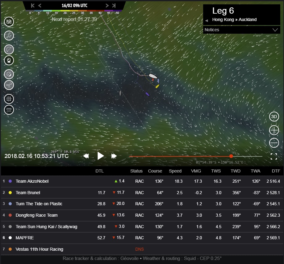
The first couple of days after the last review passed pretty much as anticipated, with the fleet racing south in the trade winds. If we check out Image 2 from 12:00UTC on the 15th February, we find the fleet about to hit the Doldrums, and Team AkzoNobel (purple) has worked hard to close out their leverage with the chasing pack. They now have the second and third placed boats, MAPFRE (white) and Team Brunel (yellow) more or less in line behind them, at the expense of half their lead – down to 26 miles.

©Geovoile - Image 2 (Click for larger image)
Not everyone was playing the same game though – after closing leverage with the fleet for most of the previous two days, Team Sun Hung Kai/Scallywag (grey) decided about 12 hours prior to Image 2 that they would tackle the Doldrums further to the west, and started to sail a wider wind angle and a faster course. It turned out to be a very smart move.
West not east
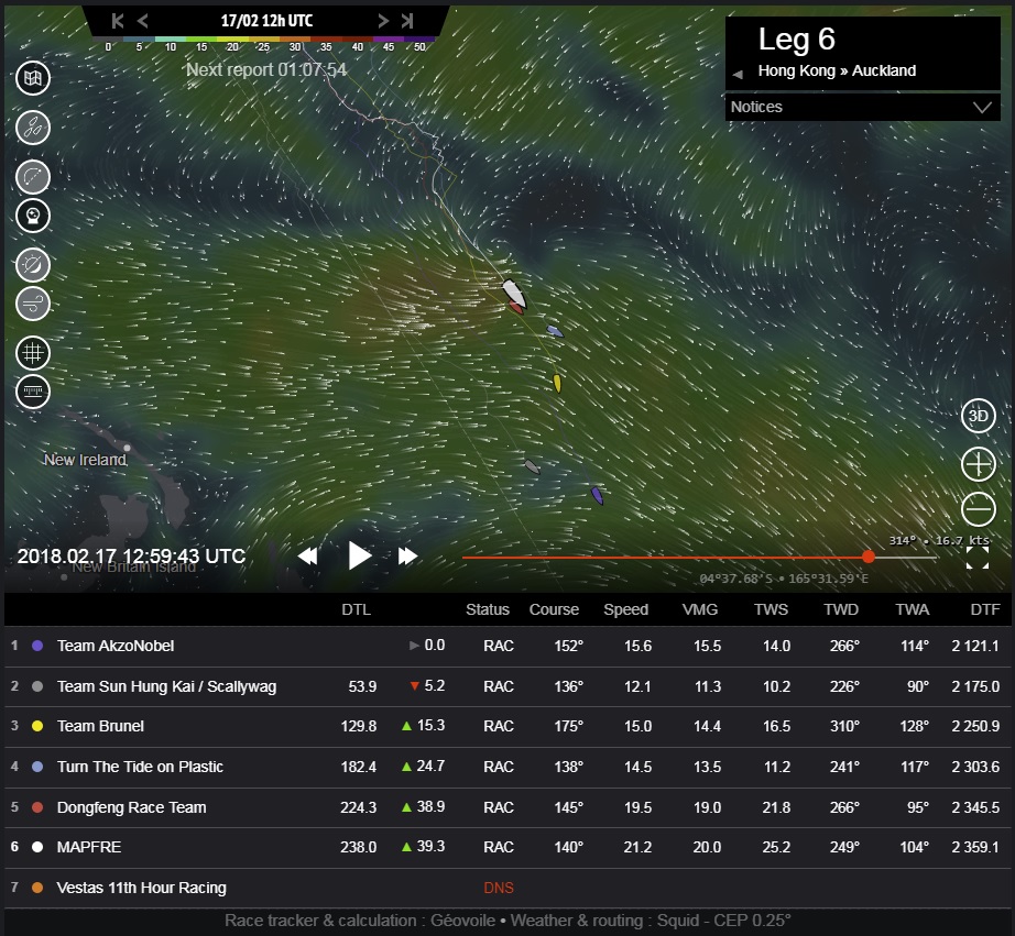
If we look at Image 3 from 11:00UTC on the 16th February, this forecast still had the east as the place to be – there was more wind to the east, and a narrower band of light air. The most easterly boat, Turn the Tide on Plastic (light blue) had moved up to third place in the rankings, and both Dongfeng Race Team (red) and MAPFRE had made a big effort to get further east (rather than south, which was Team AkzoNobel and Team Brunel’s strategy).

©Geovoile - Image 3 (Click for larger image)
Unfortunately for the two overall leaders, this forecast was wrong and the clue was there in Team AkzoNobel’s wind speed – 16 knots. The leg leader had found the westerly breeze on the south-side of these Doldrums and was already moving. Perhaps even more remarkably, she was soon joined by the Scallywags.
One cloud?
It looks like it could have been as simple as finding one extra cloud, the Volvo Ocean Race @RaceExperts team posted this satellite image from that time:
1148 Ut Tracker Update - @teamAkzoNobel have made huge gains on the rest of the fleet and are sailing in 10-12 knots from the West. Meanwhile, the rest of the fleet is still drifting in < 5Knots. #WatchLog pic.twitter.com/PoCX8GNKfN
— Race Experts (@RaceExperts) February 16, 2018
It shows that Team AkzoNobel got something that no one else had... whatever, Team AkzoNobel and Team Sun Hung Kai / Scallywag managed to cross what should have been a windless desert, hit the westerly breeze on the south side of the Doldrums and put the hammer down.
Team AkzoNobel had to gybe in a north-westerly shift for a while, but by Image 4 at 18:00UTC on the 16th February they were clearly out, enjoying 18-20knots of westerly breeze with the rest of the fleet trapped behind them in four to five knots of light northerly wind.

©Geovoile - Image 4 (Click for larger image)
Painful consequences
It took a long while for the rest of the fleet to clear this section of Doldrums. We can see in Image 5 from 13:00UTC on the 17th February that Team AkzoNobel and the Scallywags were making hay while the sun shone. The leader was now 130nm clear of third placed Team Brunel, while a full hundred miles further back, Dongfeng Race Team and MAPFRE must have been rueing the moment when they parted from Team AkzoNobel’s track to go east and not south.

©Geovoile - Image 5 (Click for larger image)
The run ended for Team AkzoNobel less than a day later though, as we can see in Image 6 from 06:00UTC on the 18th February.

©Geovoile - Image 6 (Click for larger image)
This time they hit the wrong kind of cloud – as you can see in this @RaceExperts satellite image:
0906UT Position update- @teamAkzoNobel are back in 10 knots of wind but at a cost of about 60Nm. Here are the satellite images showing what happened. #WatchLog pic.twitter.com/JpUiIuUAo1
— Race Experts (@RaceExperts) February 18, 2018
And while they suffered a windspeed of just three knots, the Scallywags charged right past them to take the lead.
Across the Westerlies
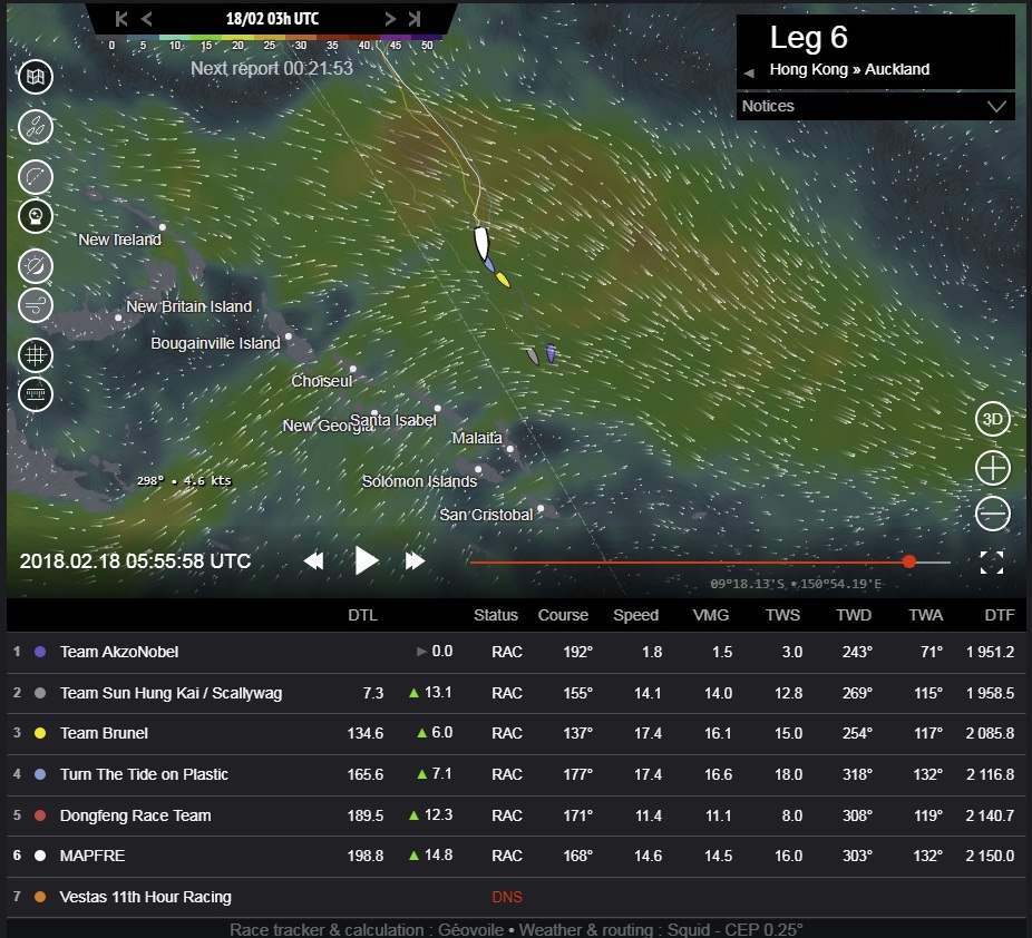
It didn’t take long to cross the band of westerly wind, and I’ve zoomed out in Image 7 from 11:00UTC on the 18th February so we can see why. I mentioned Cyclone Gita earlier, and the storm is visible at the bottom centre of this image, just to the east of Brisbane.

©Geovoile - Image 7 (Click for larger image)
The cyclone is the reason why they exited the band of Doldrums into a westerly wind, rather than the south-easterly trade winds. Gita has laid waste to the trades as it has moved west and south through the region, although you can see then re-emerging in the bottom right of the image. So the westerly wind, created by Gita’s exhaust running up the east coast of northern Australia, was always going to be short-lived. And another transition into a second band of even bigger Doldrums conditions was up next.
Recompression
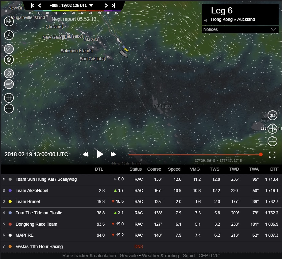
If we zoom in and bring it up to date we can see how much the fleet has recompressed as they have hit the second Doldrums. In Image 8 from 13:00UTC today, 19th February we can see that the whole fleet is now in this changeable, unpredictable weather.

©Geovoile - Image 8 (Click for larger image)
Team Sun Hung Kai/Scallywag and Team AkzoNobel are locked together at the front, but after getting within three miles of them, Team Brunel has lost out again as the leaders found a cloud with some breeze and scarpered.
The leaders have also made gains again on Turn the Tide on Plastic, almost 40nm behind, with the overall leaders, MAPFRE and Dongfeng Race Team probably not enjoying the unusual experience of bringing up the rear – although they can take some consolation that the deficit is still in double figures. Just.
Slow, and slower
The Predicted Route calculations aren’t going to be much help from here this time, as it’s very hard for the software to be accurate when there is so little wind around, and the local cloud effects are so important. This could be one of the most challenging sections of the entire race. It will be fought out on those local effects. The navigators will be glued to the rain radar and satellite imagery to see where the next gust is coming from, and then working on how to try and optimise it.
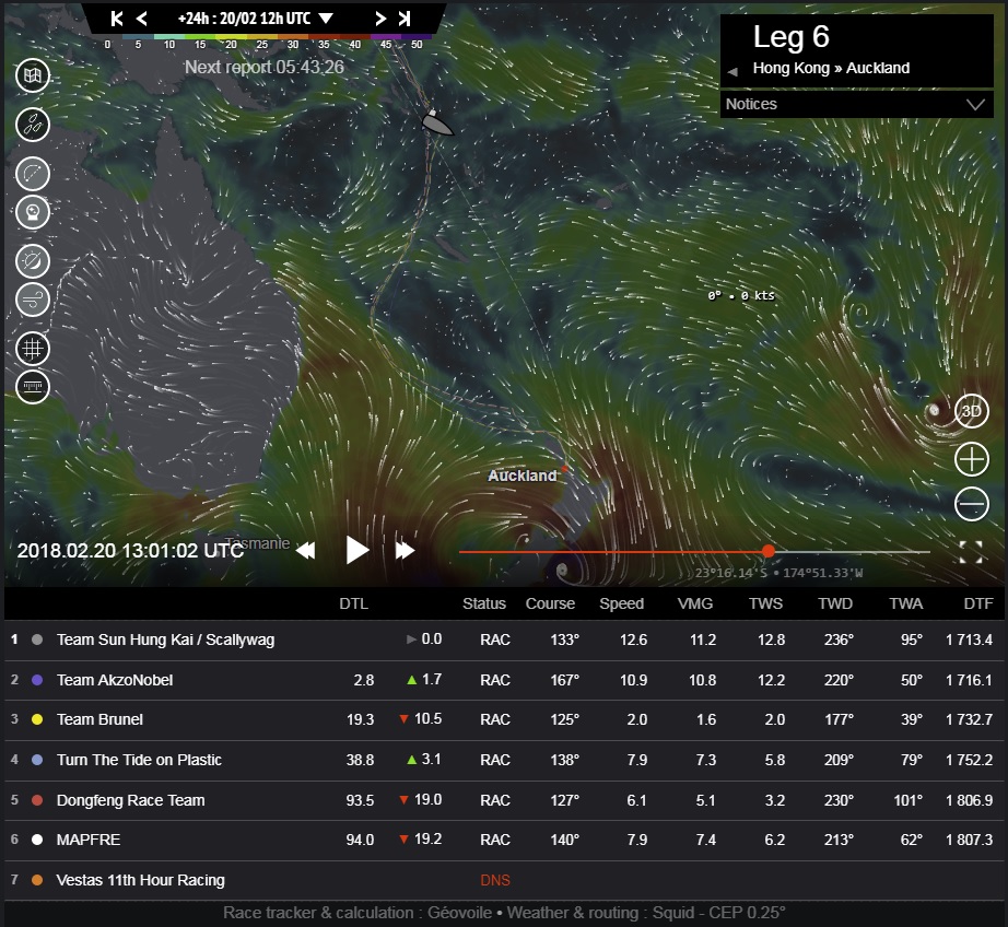
24 hours
We will step through the next few days to get a rough idea of what’s ahead. In Image 9 from 13:00UTC on the 20th February (24 hours ahead) Cyclone Gita is moving to the east, crossing New Zealand’s South Island, and a second system is setting up in its wake, just to the west of the South Island. To the north of that there is very little pressure gradient anywhere near the route to Auckland (shown by the grey dashes).

©Geovoile - Image 9 (Click for larger image)
In Image 10 from 14:00UTC on the 21st February we can see that the easterly wind flowing across New Caledonia and on to Australia is starting to spread north towards them.

©Geovoile - Image 10 (Click for larger image)
72 hours
In Image 11 from 13:00UTC on the 22nd the fleet have got into that wind, which is strengthening as a high pressure sets up to the east of Tasmania in the Tasman Sea. The problem will be – if it turns out like this – that they are going to end up sailing west of New Caledonia and ending up north-west of Auckland in a south-easterly wind with a long upwind slog to the finish.

©Geovoile - Image 11 (Click for larger image)
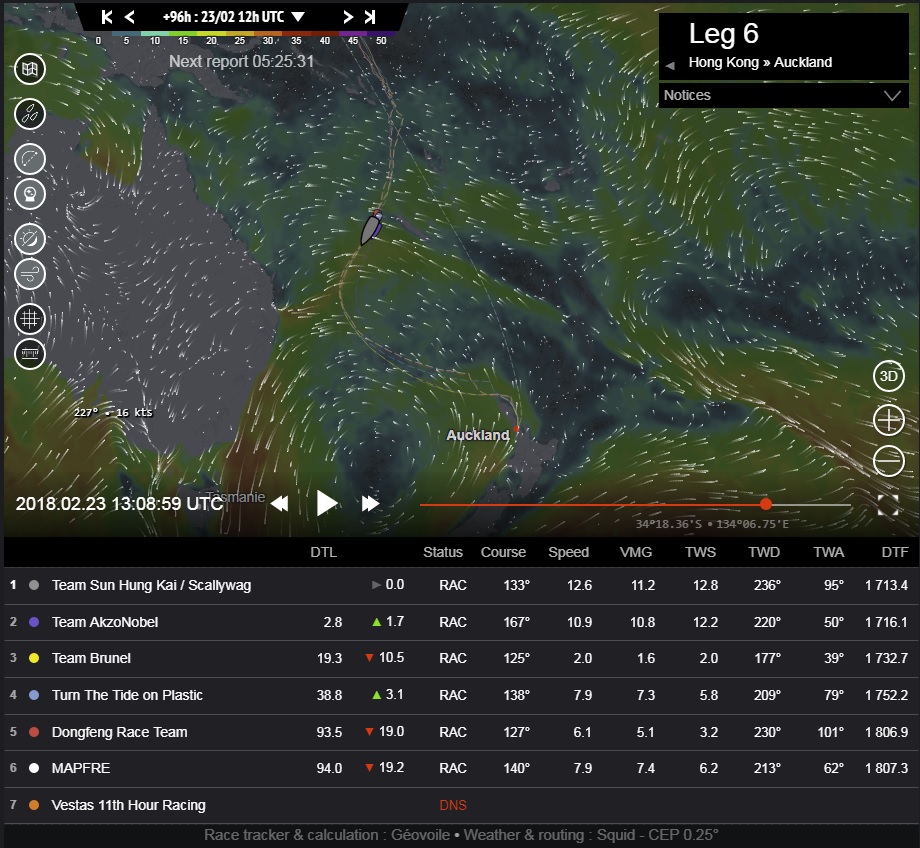
We can see this in Image 12 from 13:00 UTC on the 23rd February, where the high is now well established in the Tasman Sea and they are looking at an upwind course to the top of New Zealand.

©Geovoile - Image 12 (Click for larger image)
Another 24 hours on in Image 13 from 13:00UTC on the 24th February, and we can see that the high is now being pushed eastwards, as a low pressure system rips up from the Southern Ocean and through Bass Strait.

©Geovoile - Image 13 (Click for larger image)
This will bring plenty of wind, dragging the direction into the north, and turning the final miles to the top of New Zealand into a wet and wild reach: chased by the front ahead of the low pressure – as we can see in Image 14 from 13:00UTC on the 25th February.

©Geovoile - Image 14 (Click for larger image)
Unreasonable speculation
Now this was unreasonable speculation based on a shaky forecast at 48 hours ahead of the current situation – never mind six days ahead – but it does at least show why the Predicted Route wants to drag everyone to the west. The only real wind on the race course in the foreseeable future will come from that low pressure.
I don’t see that there are any big strategic options here. While the southeast trades will be restored and blowing over Fiji for most of this period, getting there means sailing directly downwind in very light air. It would take forever to get to the breeze at the islands, add hundreds of miles to the race track and even then it doesn’t look like there will be much wind to the north-east of Auckland for a final approach coming from Fiji.
It does look like playing the local effects to get south, while staying on or west of the rhumbline is the best option, but of course I’ve been wrong before, as recently as six days ago... So this time I will leave you to make up your own mind, and I’ll be back with the wisdom of 20/20 hindsight when it’s all played out.
