
We are two days and change into Leg 6 of the Volvo Ocean Race – and one of the physically toughest sections of the race has now turned into one of the most strategically demanding as a big split in the fleet opens.
We have two boats – Team AkzoNobel and Team Sun Hung Kai / Scallywag – already 120 nautical miles (nm) to the north-west of the rest of the fleet, a huge amount of leverage this early... but hold on...
Leverage is measured perpendicular to the course to the finish, and that’s in Auckland some 6,100 nautical miles to the south-east of the start line in Hong Kong. So why is the 120nm north-west split leverage in a strategic play, rather than a straight-forward gain / loss?
Let’s back up a bit.
 © Jeremie Lecaudey/Volvo Ocean Race
Climate Zones again
If you’ve been following these strategic reviews – and particularly if you were following Leg 4 – then you’ll be very familiar with the idea of Climate Zones. Check out the Leg 6 Preview for the full story but briefly, just know that the earth’s oceanic climate features distinct bands, lying horizontally and looping the globe, running out from the Equator to the Poles in a mirror image.
When the fleet races from north to south (or vice versa) as they are right now, then they will cross through several of these climate zones and the transitions from one type of weather or climate zone to the next becomes a critical feature of the strategic game.
Monsoon Opening
The opening part of Leg 6 is usually dominated by the task of getting across the South China Sea and through the North-East Monsoon (a powerful wind created by the clockwise flow around a huge seasonal high pressure over central Asia) in one piece, before transiting into the north-east trade winds, and then setting up for another crossing of the Doldrums.
In each of the last three races at least one boat has made a strategic move to the east early on, rather than keeping to the straight-line, shortest distance route that clips the top of the Philippines and then heads south-east (this route is shown by white dashes on the Race Tracker). The ‘easterly variation’ ultimately provides a better wind angle in the trade winds, and a narrower crossing point for the Doldrums – something we will come to in more detail in future reports – but it’s also a lot more miles to sail. This is a classic race strategy problem; trading extra miles for extra speed.
The ‘easterly variation’ – a short history...
In 2014-15, Team Brunel (navigated then as now by Andrew Cape) and Team SCA (navigated by Libby Greenhalgh, now aboard Scallywag) made a big move, going north-east out of the South China Sea and eventually coming out in front of those that sailed the straight line to the top of the Philippines.
In the race before that, Puma took a route to the north and then east before they finally turned south in better breeze. They sailed past the fleet – who were miles to their west – to end up in second place. In the previous race it was Ian Walker that took Green Dragon on an eastern adventure that – despite a slow boat – did just fine.
So the two options are the straight-forward, straight-line route to the top of the Philippines (which effectively reverses the route they took to Hong Kong on Leg 4); and then there’s this easterly variation in which the boats need to head north-east into the Pacific rather than south-east – which is why the current split is leverage, and not the straight-forward lead you see on the leaderboard... phew.
Boat breaker
So much for the big picture, the first problem out of the starting gate was surviving.
The North-East Monsoon has a bad reputation for breaking boats and on other occasions in previous races virtually the whole fleet have had to take shelter from its wrath.
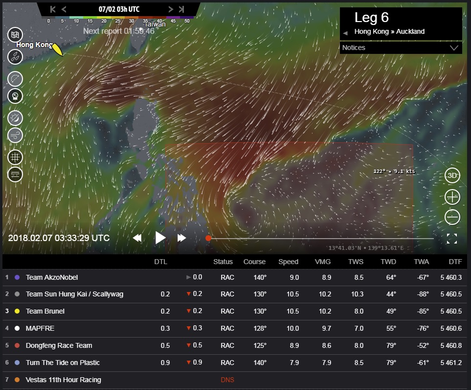
If we look at Image 1 from 0330UTC on the 7th February, just after the start, we can see a relatively normal weather pattern for the first section of the leg out into the South China Sea. The strong north-easterly wind was screaming around Taiwan and converging right on the route of the fleet as they headed south-east.

©Geovoile - Image 1 (Click for larger image)
This section was always dominated by the need to keep the boat in one piece in these brutal upwind conditions, and this year was no different. It’s what’s coming next that changes the game.
Game changer – the cyclone
The first clue is at the bottom centre of Image 1 (just to the east of the Philippines) where you can see a powerful tropical cyclone spinning up. It’s sucking air into it from the North Pacific and turning what should have been a relatively benign section of the leg – a beam reach in the north-easterly trade winds down past the Philippines – into a life-threatening hazard.
The race officials have understandably put this area off limits, and if we look at Image 2 from 15:00UTC on the 8th February, we can see the implications. The (faintly) red shaded box marks the exclusion zone, and it’s created a waypoint (a corner to go around) a long way out to the east in the Pacific.

©Geovoile - Image 2 (Click for larger image)
The fleet have to get around this before they can turn south to head for Auckland. They are effectively all being forced to take the easterly variation that has worked rather well for teams in previous races. Of course, the devil remains in the details...
Go east...
So the whole fleet started with a strategic need to get east, rather than south-east, and didn’t reverse their course from Leg 4 back to the northern tip of the Philippines. In the first 36 hours of the race the wind made it easy (strategically if not physically); the breeze was blowing from the north, down the channel that separates Taiwan from the Asian mainland. So everyone could happily sail due east, taking them to the southern tip of Taiwan. It was once they had cleared this headland that the options opened up.
The split
If we have a look at Image 3 from 19:00UTC on the 8th February we can see that the fleet cleared Taiwan, and hit a very significant wind shift. It went from the northerly they had to the west of Taiwan, to an easterly wind on the eastern side of the island. This left them with the choice of going north-east, or south-east.

©Geovoile - Image 3 (Click for larger image)
They were already a long way north of the straight-line route, and so both options were possible. Team AkzoNobel and Team Sun Hung Kai / Scallywag chose to tack and go north-east, while everyone else took the heading wind shift and went south-east.
Tactical split
We’ll come to the big picture reasons for tacking in a moment, because as it turned out, everyone wanted to go north-east. It looks like the decision driving the initial split was more a short-term tactical one.
Check out the lighter wind (the blue area) between the northern pair of boats and Taiwan – it looks like this is created by the wind lifting over the high mountains of the island. Now go forward to Image 4 at 23:00UTC on the 8th February and we see that everyone else has now tacked and the whole fleet is headed north-east.

©Geovoile - Image 4 (Click for larger image)
There is a big difference in wind speed between the boats that tacked early (Team AkzoNobel and Team Sun Hung Kai / Scallywag) who have 11-16 knots, and the rest of the fleet that tacked later, who have 21-25 knots. It looks like the early tackers went too early, and are positioned too close to the coast of Taiwan.
And then it got worse...
Up to this point it made sense; the conditions being reported from the water matched the weather maps. And then we look at Image 5 from 09:00UTC this morning, 9th February and it no longer makes sense. Team AkzoNobel and Team Sun Hung Kai / Scallywag should have escaped from Taiwan’s influence, and got themselves back in good breeze, with the weather map saying they have 20 knots from the south-east, just like the rest of the fleet – but this hasn’t happened.

©Geovoile - Image 5 (Click for larger image)
In fact, they have 2-5 knots from all over the place as we can see in the table below the chart. I think there are two possible reasons. We can see the first in Image 6, also from 09:00UTC this morning, 9th February where the two boats are close to a couple of quite high islands – Taketomi and Ishigaki, marked on the chart in grey. It’s possible that the mountains have messed up the breeze, something we probably wouldn’t see on the global weather charts we are using.

©Geovoile - Image 6 (Click for larger image)
Unstable conditions
If we now zoom out a bit in Image 7 – still from 09:00UTC on the 9th February – we can see that a low pressure system is spinning up at the northern tip of Taiwan. It looks to be a consequence of the North-East Monsoon blowing down the western side of the island, while a south-easterly flow (from a high pressure system to the north-east of Taiwan) hits the eastern side.

©Geovoile - Image 7 (Click for larger image)
It’s fair to say that having the wind blowing in 180 degree different directions down two sides of a mountainous island isn’t a particularly stable situation, and it’s possible that this is consequently developing very differently to the way the forecast predicted.
In which case, it could have a big impact on how this plays out, as that low pressure and the front that goes with it are the key to the next couple of days. And that’s a good segue – time to bring it up to date and have a look at the bigger picture – why did everyone want to tack and go north-east in the first place? Why is the easterly variation going so far north?
Up to date
Image 8 is up to date with the time of writing – 13:00UTC on the 9th February – and we can see on this close-up image that Team AkzoNobel and Team Sun Hung Kai / Scallywag have got a little further north, away from the islands, and the breeze has started to fill in for them. It’s now 9-11 knots – so a wind shadow from Taketomi and Ishigaki looks a likely explanation for their slow progress.

©Geovoile - Image 8 (Click for larger image)
We can also see that the low to the north of Taiwan is gathering some strength, and it’s the movement of this system that will dominate the next few days. In Image 9 we can see that in just a few hours – 18:00UTC on the 9th February – the low will be generating a lot of breeze and moving to the north-east. It’s trailing a front to the south-west of its centre and the whole fleet will now be getting the strong southerly wind ahead of this front – with the northern boats closer and in quite a bit more breeze.

©Geovoile - Image 9 (Click for larger image)
Racing the low
The shift from the south-easterly breeze they have now to the southerly they will have by this evening (UTC) is reflected in the slow curve of their predicted route (the faint dashed lines on the Race Tracker). The wind shift allows them to eventually head east again and they will now start to race the low pressure system and the front as it also heads east from behind them.
Crossing the front...
I think that the timing of this part is a little unpredictable, but in Image 10, the predicted route and weather on the Race Tracker says that around 19:00UTC tomorrow, 10th February the front will catch both the northern pair and the rest of the fleet at about the same time.

©Geovoile - Image 10 (Click for larger image)
By this time there will be more wind behind the front. This wind is blowing from the north-west, so once the front has overtaken the fleet, they will be flying downwind as they continue the trek east into the Pacific. Getting the north-westerly a little bit earlier should benefit the northern pair and help them make up the losses they have suffered so far.
And now we can finally see on the weather map why this easterly variation is going so far east this time – there’s a big area of high pressure and light wind forming on the straight line route to Auckland and spreading from there to the east. The whole reason for the tack to the north-east last night was to get away from this trap.
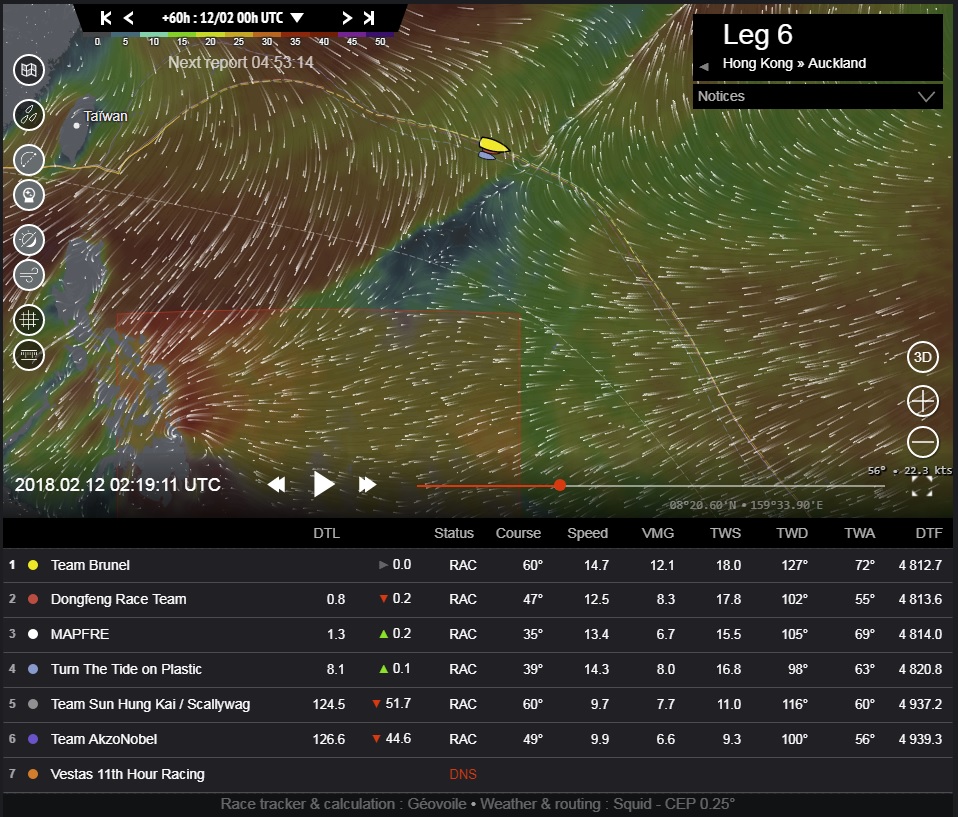
This area of high pressure will continue to dominate the strategy for another couple of days at least. If we look at Image 11 we can see the predicted boat positions and the weather at 02:00UTC on the 12th February. If the predictions are correct the fleet will have come back together and remarkably, the split will have converged with almost nothing in it. Partly because they will all be bumping into the back of the front as it slows in front of them.

©Geovoile - Image 11 (Click for larger image)
Crossing the front... again
The north-east trade winds are blowing strongly on the right of this image, and there’s no question that this will be the end game. The question is how they will transition back through the front – dodging what’s left of the high pressure as it drifts to the east ahead of them – to break into the trade winds.
If we go forward another 30 hours to 08:30UTC on the 13th February in Image 12 we can see that the front has stalled and is fading. The fleet’s wind is rotating clockwise into the north-east, and all that’s between them and the (real) trade winds is the final, fading bubble of high pressure.

©Geovoile - Image 12 (Click for larger image)
It’s likely that the fleet will compress again as it hits this light wind – it also looks likely that boats to the west will have an easier and narrower band of light wind to transit. And whoever gets through this into the trade winds first will hold their lead (speed being equal) until they get to the Doldrums.
It’s going to be a very interesting weekend – and I’ll be back early next week to see how it plays out.
