
The fleet is three days into the fourth leg of the Volvo Ocean Race and we’ve seen the first big strategic play conclude with gains of thirty miles for Dongfeng Race Team and Team AkzoNobel. Only to see a small tactical error hand most of the advantage back to the chasing pack.
It’s been a fascinating opening few days of this leg as the lead pair crafted a strategy that took advantage of an eddy in the East Australian Current, and some better breeze offshore. This is the first time we’ve seen ocean currents play a role in the race strategy, and I’m sure it won’t be the last.
The current wasn’t the whole story though, and the climate zones that we have become very familiar with over the past couple of months played their part. In this case it was two powerful areas of high pressure – one to the west of Melbourne, and one to the east – and a building storm bound for New Zealand.
Climate Zones again
Let’s take a quick look at the overall strategy for the opening section of the leg – if you want the full version, then check out the Leg Preview for Leg 4. If you’re short on time then just know that the earth’s oceanic climate features distinct bands, lying horizontally and looping the globe, running out from the Equator to the Poles in a mirror image.
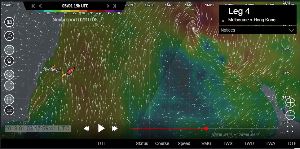
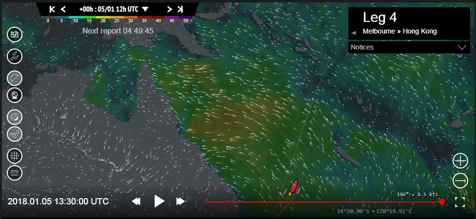
Over the opening three or four days of Leg 4 we only had to worry about one of these climates zones; the stable, semi-static areas of Subtropical High Pressure that sit around the latitude of 30N and 30S in each hemisphere. At almost 38S, Melbourne normally sits around the southern limit of the high pressure zone in summer, and this is exactly the situation we saw as the race started on Tuesday, 2nd January; take a look at Image 1, from 19:00UTC, the evening of the first day.

©Geovoile – Image 1 (see larger image)
Two highs
On the left hand side of Image 1 we can just see the anti-clockwise rotation of the wind around a big centre of high pressure in the Great Australian Bight. The south-westerly wind around the bottom right-hand quadrant of the high is flowing through the Bass Strait. We can see the red and orange of a very solid breeze accelerating and bending around Cape Howe and up the eastern coast of Australia.
Beyond that breeze, on the right-hand side of Image 1 we can see a second, even bigger area of high pressure dominating the western Pacific, the light winds indicated by the blue and green areas.
Wind bend
The opening couple of days were dominated by this set-up with some fast downwind sailing. To make gains, teams need to utilise the wind shifts, and the wind bend around Cape Howe. This is yet another example of one of our hoary old rules; always head for a headland. The wind invariably bends around a headland, and since the fast route through a wind bend is on the inside of the bend, that means keeping close to the coast.

©Geovoile – Image 2 (see larger image)
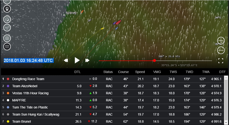
Around Cape Howe
If we look at Image 2 from 06:00UTC on the 3rd January we can see that the whole fleet adopted this strategy while approaching and rounding Cape Howe. It kept them very tight as a group with only 11 miles between the leader, Team AkzoNobel (purple) and Turn the Tide on Plastic (light blue) in seventh. This is the moment when the consensus ended though, as a big split developed in the fleet right after Green Cape.
The big split
We can see in Image 2 that Team AkzoNobel, Dongfeng Race Team (red) and Turn the Tide on Plastic took a more easterly, offshore route that the others. Furthest west, or inshore are MAPFRE (white) and Vestas 11th Hour Racing (orange), with Team Sun Hung Kai / Scallywag (grey) and Team Brunel (yellow) in the middle.

©Geovoile – Image 3 (see larger image)
Let’s zoom out on the weather chart for a moment to take a look at the bigger picture in Image 3 from 18:00UTC on the 3rd January. The high pressure dominating the Western Pacific has moved to the east, offshore, and is being snuffed out by a building low pressure system that has set up a strong southerly wind along the New South Wales coast.
New Zealand storm
This sub-tropical storm was headed south where it hit northern New Zealand on Thursday 4th January causing power outages and flooding. It was important to the fleet because it created a difference in the wind strength – more wind to the east, closer to the storm, and less to the west, closer to the east coast of Australia.
East Australian Current
The wind was only one factor in the split though, the other was the East Australian Current (EAC) which flows southwards down the east coast of Australia, bringing warm water from the Equator.

Image 4 (see larger image)
If we look at Image 4 (with thanks to Gonzalo Infante, Race Meteorologist for this one) we can see the EAC plotted on a chart of the east Australian coast just south of Sydney. The EAC is not just flowing south, it’s also eddying and creating a circular flow with a strong component headed back north around the latitude of Canberra. It was this eddy that the offshore boats were targeting.
There were a couple of ways to skin this cat though; it’s clear from Image 4 that going offshore wasn’t the only way to avoid the strong southerly flow of the EAC – getting close to the beach also helped, with the current fading close to the shore.
Inshore or offshore?
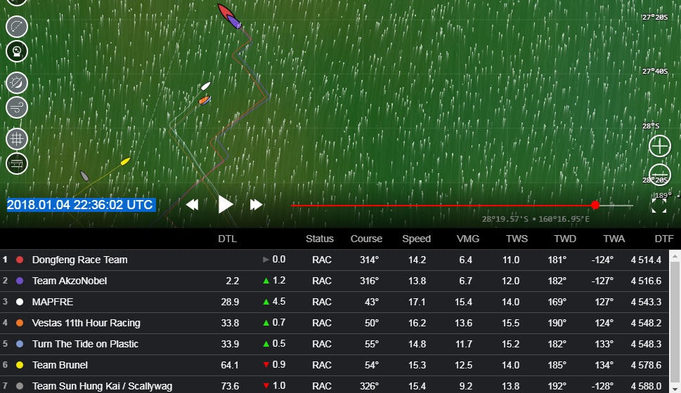
If we look at Image 5 from 16:30UTC on the 3rd January 2018 we can see that MAPFRE and Vestas 11th Hour Racing have now committed to the inshore option, with Dongfeng Race Team, Team AkzoNobel and Turn the Tide on Plastic staying offshore, and Team Brunel and Team Sun Hung Kai / Scallywag still in the middle.

©Geovoile – Image 5 (see larger image)
At this point, the only thing that’s absolutely certain is that the middle isn’t working – refer back to Image 4 and you’ll see that these latter two boats were punching the worst of the current through this period and already making losses.
Vestas 11th Hour Racing and MAPFRE weren’t doing too badly, holding third and fourth respectively and only ten miles or so behind the leader. The wind speed difference was starting to show though – 23-24 knots offshore, and 15-18 knots inshore – and this would slowly make the difference.
By midnight 24:00UTC on the 3rd January we can see in Image 6 from the leaderboard that the wind speed differential is still there, benefitting the three offshore boats.

©Geovoile – Image 6 (see larger image)
Inshore, MAPFRE and Vestas 11th Hour Racing have now passed the worst of the southerly flow of the EAC shown in Image 4 and turned to a more north-easterly course to move offshore.
This is closing the leverage down (the distance between the boats measured perpendicular to the course) and Dongfeng Race Team, Team AkzoNobel and Turn the Tide on Plastic are popping out in front with a very handy lead.
Results come in…
A couple of hours later the leaders gybed back to the north-west, and by 06:00UTC on the 4th January in Image 7 we had the whole fleet more or less lined up along the route. Once the leverage is close to zero we can see clearly the results of the inshore / offshore split.

©Geovoile – Image 7 (see larger image)
Dongfeng Race Team and Team AkzoNobel had gained over thirty miles relative to Vestas 11th Hour Racing and MAPFRE, with the ‘middle route’ boats, Team Brunel and Team Sun Hung Kai / Scallywag taking an even bigger pounding, now around sixty miles behind the leader.
Playing the shifts
The fleet was now powering north in a southerly wind, the breeze still spewing off the storm laying waste to parts of Auckland’s power grid. This meant they could start gybing, looking for advantage in the wind shifts and wind strength differences.
Over the next 15-18 hours not much changed, although MAPFRE picked off a couple of boats. The leaders were also moving into a lighter wind first – because the fleet was sailing away from the big low pressure – so the whole fleet started to compress.
By 22:30 of the 4th January in Image 8 we can see that MAPFRE are up to third, and the compression has meant that they are now 30 miles behind Dongfeng Race Team.

©Geovoile – Image 8 (see larger image)
Along with Team AkzoNobel, the Chinese team had got themselves squarely back in front of the chasing pack (MAPFRE, Vestas 11th Hour Racing and Turn the Tide on Plastic), and put in a gybe to get on the same course as them. And then, for some reason, they did a second gybe quite soon after to go back to the north-west.
Looking for a gain?
The most likely reason is that they thought they would gain from a wind shift. The whole fleet had been optimising the oscillations in the wind as it shifted between about 180 and 210 degrees. In the 180 wind direction, everyone wanted to be on starboard gybe, and in the 210 wind direction they wanted to be on port.
Taking losses
After they gybed to port to go north-west, Dongfeng and AkzoNobel had around a 180 wind direction (shown in the leaderboard in Image 8), which was not good for port gybe, and it must have been clear quite quickly that they had made a mistake. In Image 9 from 01:00UTC on the 5th January both Dongfeng and AkzoNobel have gybed back to starboard in a position 44 miles north-west of MAPFRE.

©Geovoile – Image 9 (see larger image)
The advantage had already been cut to 16 miles thanks to the 150 minutes the leaders have been sailing on the wrong gybe for the wind direction. Things now got even worse for the lead pair, as MAPFRE and the chasing pack got a further shift, as it went through 180 to 170. They also got a touch more breeze that Dongfeng and AkzoNobel didn’t see for quite a while.
By 06:00UTC this morning, 5th January, MAPFRE had taken good advantage of Dongfeng’s error. In Image 10 we can see the track of the Spanish boat (white) slowly converging with Dongfeng Race Team (red) – and the leaderboard tells the story with the gap now down to just 5 miles.

©Geovoile – Image 10 (see larger image)
Trade winds
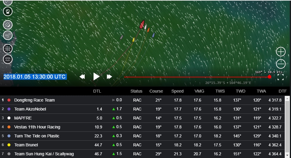
If we now bring the picture up to date with Image 11 from 13:30UTC today, 5th January, we can see that the whole fleet has converged as the wind has continued to shift into the south-east. The fleet now has a direction of between 130 and 150, and the windspeeds are also pretty consistent at between 16 and 18 knots. Welcome to the trade winds.

©Geovoile – Image 11 (see larger image)
If you’ve been following these Strategic Reviews since the start, or you’ve read the Leg 4 Preview then you will know that we are back on familiar territory – racing from the south to the north through a sequence of climate zones.
If we look at the big picture in Image 12 from 13:30 today, we can see the south east trade winds ahead of the fleet, stronger to the west than the east – which is why Dongfeng’s losses have stopped. It looks quite a bit lighter around New Caledonia, in what’s called the South Pacific Convergence Zone. This could have created a kind of double Doldrums effect if the fleet had been further east.

©Geovoile – Image 12 (see larger image)
As it is, they have around 800 miles to Santa Ana Island (a mark of the course that will force them to the east of the Solomon Islands) in solid but slowly easing south east trade winds.
Payback time
This brings us to Image 13 from 21:00UTC on the 7th January – Sunday evening UTC, or Monday morning local time for the boats. If you believe in karma then this is payback time. The fleet had a really easy ride through the Atlantic doldrums on Leg 2, but this looks much worse. The area of light wind stretches north ahead of them all the way past the Solomon Islands and Papua New Guinea.

©Geovoile – Image 13 (see larger image)
In the worst case it’s about a thousand miles of lighter, shiftier conditions and it could take a few days to cross it. It does look like the breeze will pick up in the east first, and we may well see the fleet chasing each other out to that side, as I doubt anyone will want anyone else to get any leverage to the east.
North east trades
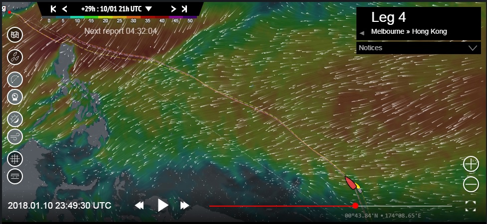
By midnight on the 10th January (next Wednesday) in Image 14 the predicted optimum route calculated on the Race Tracker puts them into the north east trade winds. They will now be facing a long, fast starboard tack reach to the northern tip of the Philippines. At this moment, it doesn’t look like there’s another gybe till the 15th January – so whoever gets out of the Doldrums and into the north-east trades first has a very high percentage chance of winning this leg…. as long as they are fast on a reach.

©Geovoile – Image 14 (see larger image)
It’s going to get stressful
After a couple of pretty easy days they are headed for a very stressful 72 hours – or maybe more – starting Saturday night UTC. The charts are showing bands of decent breeze and some big holes. This one will be fought out on a small scale; the winners will be those who take best advantage of the clouds and local effects that are the essence of any Doldrums crossing.
How close to the islands?
One big question will be how close to get to Santa Ana at the eastern tip of San Cristobal Island. In daylight the heating of the islands might create an onshore sea breeze. Or, the wind could lift over the mountains of San Cristobal and create a hole in the breeze. At night, there could be a katabatic or drainage wind off the mountains. Or there might not.
A lot will depend on the timing, if there is a sea breeze it won’t fill much before midday. The fleet should be there sometime Monday morning local time, right on the cusp of a thermal wind developing. I doubt anyone has any local knowledge; previous races have been going in the other direction, and a long way east of here – but the very well prepared teams might have done some research… I’ll be back next week to see how it all played out.
